Coastal Heritage Magazine
First Impacts: Natural Systems Face Sea-Level Rise
Barrier and hammock islands, marshes, tidal wetlands, and their plants and creatures will have to be early adapters as the warming ocean creeps higher in coming decades.
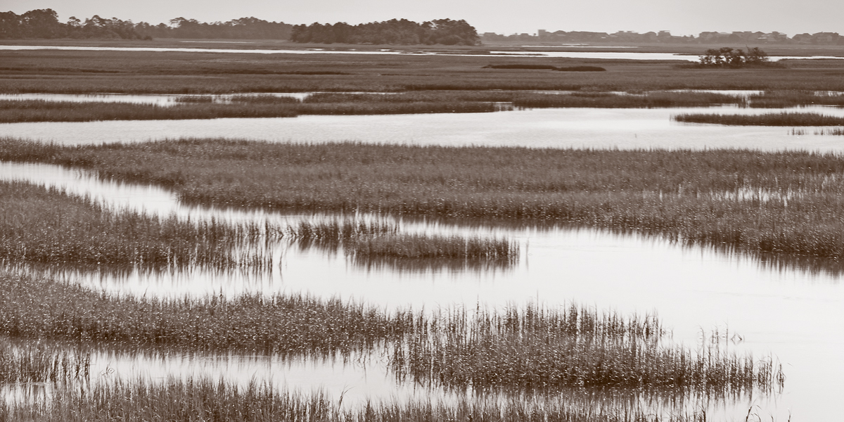
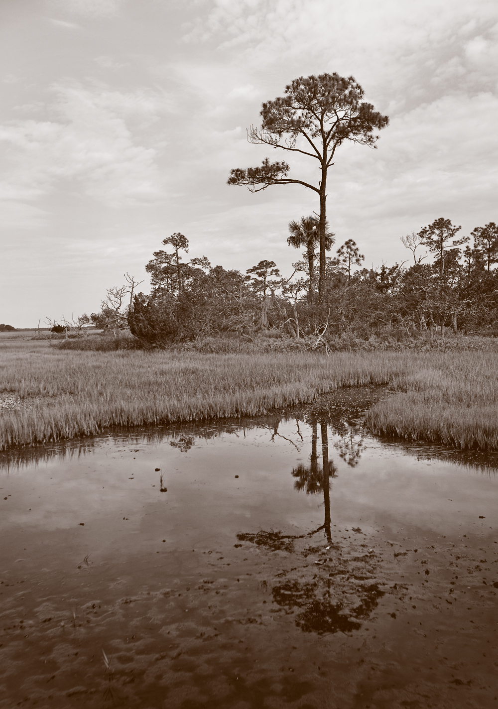
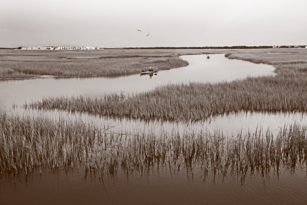
Changing Norm. As sea level rises, marshes like these behind Folly Beach will remain under water longer each day, eventually killing grasses that can’t survive constant inundation. Photo by Grace Beahm Alford.
Natural Systems Face Sea-Level Rise
Sea islands, marshes, and wetlands weave together with tidal creeks and rivers to create the unique mosaic of coastal South Carolina.
They provide a picturesque backdrop for coastal living, nurseries for creatures important to the state’s environment and economy, and short term refueling sites for migratory shorebirds. They also are ground zero for the earliest impacts of sea-level rise along the coast.
South Carolina’s jagged eastern edge is formed by dozens of sea islands – barrier islands with sandy beaches that take the brunt of ocean waves as well as several large land masses just inland surrounded by tidal creeks such as James, Johns, Wadmalaw, and St. Helena islands. The exact number depends on how far inland the islands are to be considered sea islands.
Tucked behind and between the barrier islands and large sea islands are nearly 3,500 hammock islands, sometimes referred to as hummocks. By definition, they range from 0.1 to 999 acres, with slightly more than half in South Carolina measuring less than one acre and only 12 percent larger than 10 acres, according to a 2004 survey by the S.C. Department of Natural Resources (SCDNR). The vast majority are undeveloped.
Saltwater marshes and creeks serve as connective tissue between sea islands, hammock islands, and the mainland. The U.S. Fish and Wildlife Service estimates South Carolina has about 383,000 acres of salt marsh and marine wetlands. Thousands of miles of saltwater creeks snake through the marshes and between the islands. Farther from the ocean, typically, the water becomes less salty, leading inland eventually to nearly 182,000 acres of freshwater tidal wetlands.
Someone taking a boat just a few miles up the Cooper or Santee rivers will be enveloped by freshwater tidal wetlands and their giant tupelo, cypress, and loblolly pine trees. This vertical landscape is a stark contrast to the scrubby slash pines and red cedars on the hammock islands and the smooth cordgrass of saltwater marsh stretching out to the horizon.
The commonality in each of these ecosystems is water, and that water is rising.
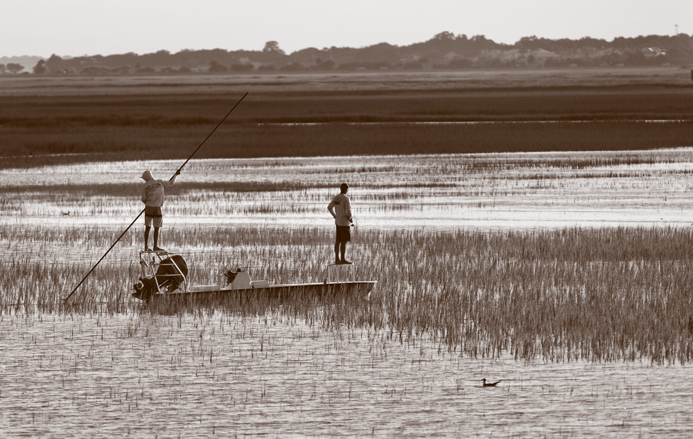
Rising Water. Anglers hit the marshes during King Tides, when the moon is closest to the Earth, causing extraordinary tide fluctuations. With sea-level rise in the coming decades, daily tides will reach heights seen only a few times a year now. Photo by Grace Beahm Alford.
Along the South Carolina coast, sea level has risen slowly over the past century, adding up to about a one-foot increase in Charleston Harbor since 1900, according to the National Oceanic and Atmospheric Administration (NOAA). As the planet’s climate has warmed more quickly in recent years, ocean water has expanded and polar ice sheets have melted. The average annual sea-level rise since 1993 has been what it was for most of the 1900s, according to NOAA’s 2017 Climate Report.
The forecasts for sea-level rise in the next 50 years vary widely. The City of Charleston consulted with NOAA in 2015 and opted to use a forecast of 1.5 to 2.5 feet for its 50-year sea-level rise planning.
The impact will be widespread throughout coastal South Carolina. While much attention has been focused on people and infrastructure, some of the first effects of sea-level rise will be on natural systems and creatures on sea islands and hammock islands and in marshes and tidal wetlands. Scientists have been studying the responses of landforms, plants, and animals to recent changes – including rising sea levels as well as increased flooding and prolonged droughts – to predict the impact on South Carolina’s coastal resources of a future with higher seas.
Can Marshes Keep Pace with Sea-Level Rise?
Marshes are equipped to adapt. Their peat-like base can migrate, as long as it isn’t blocked by the sea walls and highways of human development. They also can naturally gain elevation, and research indicates South Carolina marshes on average have accreted in recent years at rates that matched the rise of sea level along the South Carolina coast.
“Marshes have been coping with sea-level rise for 4,000 years, but at a very slow rate,” says James Morris, a research professor with the University of South Carolina (USC) Belle W. Baruch Institute for Marine and Coastal Sciences. “There’s an equilibrium, a sweet spot in the tidal range where plants can thrive and adapt. If the sea level rises more abruptly, the adaptation can’t keep up.”
Morris has been monitoring the marshes at North Inlet in Georgetown County for decades. He has seen sections of marsh disappear, specifically where rising tides in creeks have scoured their edges.
“The creeks are like pipes, and there’s more water coming into the pipes with sea-level rise,” Morris says. “There are only two ways to increase volume – more velocity or bigger pipes. And in the case of creeks, the first [increased velocity] leads to erosion of the banks and the creation of bigger pipes [or wider creeks].”
Morris’ long-term monitoring sites were originally all in marshes, but about 20 percent are now in open water. He expects the entire North Inlet will eventually become completely open water, like Pamlico Sound which separates North Carolina’s Outer Banks from the rest of the state.
The North Inlet marsh has two strikes against it – particularly low elevation and the presence of a natural sediment trap located upstream at the mouth of South Town Creek. The first marshes that will succumb to sea-level rise share these characteristics.
Healthier marshes can retreat, basically taking over land where frequent flooding has killed less salt-tolerant plants. Of course, the avenue for retreat is limited in highly developed regions, where roads, residential yards, and sea walls block movement, Morris says.
Fortunately, however, nearly a million coastal acres, mostly in the Santee River Delta between Charleston and Georgetown and in the Ashepoo-Combahee-Edisto (ACE) Basin between Charleston and Beaufort, are protected from development, giving the marshes there room to naturally retreat.
Even as marshes retreat or accrete, however, they change, says Dennis Allen, who recently retired as director of USC’s Baruch Institute. “Old marsh and new marsh don’t function the same,” he says. “They are different biochemically depending on the maturation of the soil. And the physical characteristics of the habitat drive the biological diversity and productivity.”
One study found that gently sloped creek banks have more of the worms and clams that fish, shrimp, and crabs like to eat. As a marsh retreats, it typically leaves behind steep, eroded banks that have less of these food sources.
“There’s always going to be some marsh,” Allen says. “There’s always going to be some habitat that’s ideal for some species, but we have to worry that the quality and quantity of the new habitat will not be as good as what is lost.”
Marshes also can grow deeper, as marsh grasses trap sediment flowing down from rivers or deposited by extreme tidal floods. The natural detritus when grasses die off each winter also decomposes and builds up the marsh base.
Will Doar, a SCDNR geologist, has been measuring selected marshes throughout the state for years using a Sediment Elevation Table (SET). The simple and inexpensive device features a base column driven down into solid ground. A detachable aluminum arm is inserted into the base and leveled a few feet above the surface. Then nine long pins are slipped through holes in the arm. The pins stop when they hit the marsh surface, and the portion of the pin still above the arm is measured. The changes in those measurements through the years indicate changes in the height of the marsh base.
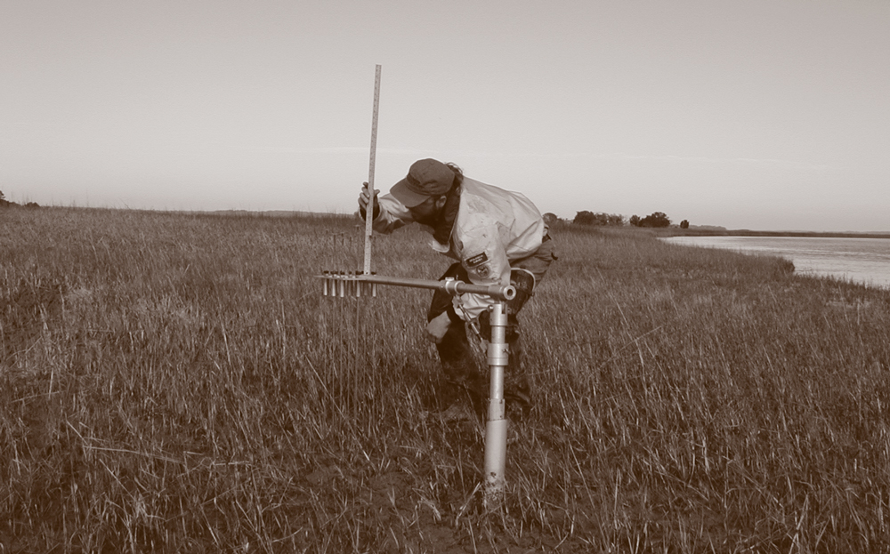
Going Up. Researchers using a Sediment Elevation Table can measure small changes in the height of marshes. In South Carolina, many marshes’ bases have risen as fast as sea level in the past century. Photo by Joseph Koch, S.C. Department of Natural Resources.
To get meaningful data, measurements need to be made over long periods. Some of the SET sites Doar has monitored in South Carolina have been studied for 20 years. Only two have been lost to erosion or severe weather. Among the others, marsh levels have dropped at a few and risen at most. In many cases, the marsh is rising fast enough to keep up with the current rate of sea-level rise. “What we have seen so far doesn’t worry us,” Doar says. “What we see makes us curious.”
For instance, the lowest stations tend to gain the most. “It’s almost like they’re trying to catch up with sea-level rise,” Doar says.
Whether the marshes can keep up with the faster sea-level rise forecast in the next 50 years is hard to predict, but the SET devices should be able to track their progress.
Increased Salinity Will Change Wetlands
Freshwater tidal wetlands located farther inland also will change as sea-level rise pushes water with higher salt content farther inland. William Conner, assistant director of the Forestry and Environmental Conservation Department at the Clemson University Belle W. Baruch Institute of Coastal Ecology and Forest Science, has tracked the condition of cypress-tupelo forests in freshwater tidal wetlands. When those ancient trees succumb to highly saline water, “ghost” forests are left behind.
Most current ghost forests in the region can be attributed to drought, Conner says. The wetlands rely on fresh water moving down-river and pushing out the more saline sea water. During droughts, the weak freshwater flow means salinity rises in the forest wetlands. As the ocean rises, however, salinity in freshwater wetlands could routinely be at levels seen now only during long-term droughts.
“Three millimeters [of sea-level rise] a year doesn’t seem like much, but it keeps adding and adding and adding and has a cumulative effect,” Conner says. “And there are still a lot of questions about how fast it will happen.”
Scientists are already considering the impacts of more ghost forests. One change will be fewer of the tall, healthy trees swallow-tailed kites prefer as nest sites on the immediate coast. Swallow-tailed kites are large, sleek raptors that seem to soar effortlessly, changing directions abruptly by adjusting their forked tails. Common in 21 states in the 1800s, these migratory birds now nest in just seven states, from Texas to South Carolina. They are listed as endangered in South Carolina, but they aren’t on the federal endangered species list.
Maria Whitehead, a former project director in South Carolina for The Nature Conservancy and now with the Open Space Institute, has been studying swallow-tailed kites for decades. She has seen some of their nesting sites on the way to becoming ghost forests. Fortunately, she says, quality forested wetland habitat exists farther inland.
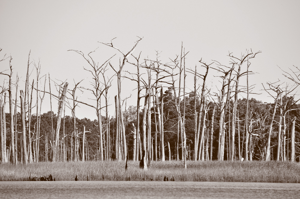
Eerie Sight. These trees near Georgetown died when prolonged droughts reduced fresh water flow down coastal rivers, thus allowing more saline water into the wetlands. As sea level rises and pushes highly saline water farther inland, more of these ghost forests will occur. Photo by William Conner, Clemson University
Conservation groups have pushed to ensure that ideal new habitat for swallow-tailed kites is protected from development and incompatible forestry practices. The Waccamaw National Wildlife Refuge, The Nature Conservancy, Open Space Institute, Winyah Rivers Foundation, and the city of Conway partnered in recent years to protect forested wetlands along the Waccamaw River to help reduce flooding in the city. The protected land could be an ideal new kite hotspot as forested wetlands closer to the ocean become inundated with high-salinity water, Whitehead says.
However, kites are social and tend to want to nest near other kites, Whitehead says. To lure newcomers inland, the Avian Research and Conservation Institute has built nest platforms that mimic active kite nests in ideal nesting trees on protected lands. This has worked in limited tests, but how well it succeeds on a larger scale remains to be seen. The Waccamaw refuge could be one proving ground.
Unable to Move, Hammock Islands Will Shrink
Unlike marshes and freshwater wetlands, hammock islands can’t migrate. Although some hammocks were created with dredge material during the phosphate mining period of the late 1800s and in the clearing of the Intracoastal Waterway in the 1930s, the vast majority have been around for centuries. Natural hammock islands formed on high spots of geological ridges just inland from barrier islands. Often those ridges are topped by shell middens – oyster and clam shells stacked thousands of years ago by Native Americans feasting in large groups over long periods of time.
Most of South Carolina’s nearly 3,500 hammock islands are in Beaufort (40.9 percent) and Charleston (38 percent) counties, according to a 2004 SCDNR inventory. Nearly 83 percent of the state’s hammock islands are privately owned, though ownership often goes back hundreds of years and is complicated by the passage of time. State law allows permitting for bridges to most hammock islands, and some of them close to existing roads have been developed, including Mingo Point near Kiawah Island and Truluck Island near Folly Island. Most remain in their natural state, representing rich, diverse, and important ecosystems.
Billy McCord, a retired SCDNR wildlife biologist, has spent as much time detailing the flora and fauna of hammocks as anyone in the state. “I can’t begin to tell you how valuable these islands are to a number of species,” McCord says. “Losing so much of them to sea-level rise will have a huge negative impact on lots of wildlife.”
McCord detailed a wealth of wildlife – 224 vertebrate species and more than 90 invertebrate species – on the hundreds of hammocks he has intensely surveyed. “It would be futile to try to protect the islands from sea-level rise,” McCord says, “but it’s important to manage the habitat now and into the future to maximize its value to wildlife.”
Protecting Spaces. One of the largest clusters of hammock islands in the state is tucked behind Kiawah Island, and many like this one are protected from development through easements with the Kiawah Conservancy. Photo by Grace Beahm Alford.
Shell deposits on most hammocks lead to highly alkaline soil, an environment ideal for rare flora such as smallflower mock buckthorn and Godfrey’s swamp privet. More common on hammocks are live oak, slash pine, cabbage palmetto, redbay, and beautyberry.
All of these plants and animals are going to have to either migrate inland or cram into a smaller habitat in coming decades. College of Charleston graduate student Matthew McCalley, in his 2012 Master’s thesis, used high-tech elevation mapping data to estimate 3.28 feet of sea-level rise would inundate 74 percent of the land area of hammock islands in the state.
That loss of habitat could severely impact species adapted to the specialized hammock environment, including the hammock crayfish (Procambarus lunzi). It is the only one of 38 species of crayfish found in South Carolina known to inhabit hammock islands.
Crayfish live in fresh water. Despite generally low elevations, most hammock islands have nooks and crannies with freshwater replenished by rain. But can crayfish and other species that need freshwater survive as hammocks become more frequently inundated with salt water by tidal flooding prompted by sea-level rise?
SCDNR researcher Michael Kendrick is tackling that question, studying hammock crayfish on Williman Island in the ACE Basin. Early results indicate the crayfish suffer salt stress as salinity levels rise. Kendrick is examining how long they survive at what levels of salinity, which could provide an indication of whether they have a future on hammock islands that are more frequently impacted by extreme high tides. And what about the crayfish on the dozens of hammocks that will be under water with three feet of sea-level rise?
“They are mobile, so they can disperse if they have to move inland,” Kendrick says. “But if they are really sensitive to salinity changes, they might not be able to make that shift.”
Studying hammock islands and the creatures that live on them over the next few years could be particularly important. Their ecosystems can serve as sentinels for how other coastal systems will respond to sea-level rise over the next half century, Kendrick says.
Human-Built Armor Impacts Barrier Island Wildlife
Unlike hammock islands, barrier islands move, mostly as their northern and southern tips erode or accrete. The classic example of barrier island movement in South Carolina is Morris Island, which over the past 75 years has drifted inland hundreds of yards because of erosion exacerbated by the sediment-grabbing Charleston harbor jetties. The Morris Island Lighthouse, also known as Charleston Light, used to be on the island along with a large caretaker’s house. Now the lighthouse is separated from the island and surrounded by water and a sand bar, and the other buildings are long gone.
South Carolina’s other large undeveloped barrier islands – such as Capers, Pritchards, and Cape – have enough central elevation to survive all but the most dire sea-level rise predictions. Governmental entities that own and manage these islands plan for the most part to let nature take its course. Their beaches are likely to retreat, eating away at their maritime forest acreage.
The real battle will be on South Carolina’s 13 developed barrier islands. Some barrier island landowners have armored their property with sea walls and rip-rap, and renourishment efforts routinely pump sand onto eroding beaches.
But these beaches and their associated dunes are more than the first defense against waves. They serve as critical habitat for wildlife, from nesting sea turtles and seabirds to the microscopic organisms that live in the sand.
Sally Murphy, a retired SCDNR wildlife biologist, worries especially about the effect losing natural dunes will have on sea turtles. South Carolina’s beaches are nesting sites for several endangered and threatened species of sea turtles, most notably loggerheads, and they tend to return to the same region of the coast each time they lay eggs. Conservation efforts, including devices engineered to reduce the bycatch of sea turtles in fishing nets, have helped boost the numbers of turtles nesting in recent years. Volunteers who have helped protect nests for several decades also have boosted hatching success. More than 5,000 nests were identified on the 48 beaches surveyed in the state in 2017.
Helping Hand. Loggerhead turtles nest on barrier islands, and they will have to deal with more eroding dunes and human-built structures as sea level rises. Eggs deposited in poor nest sites at Folly Beach are sometimes moved by volunteers to the undeveloped southeast end of the island. Photo by Grace Beahm Alford.
However, when sea turtles make the energy-sapping journey up a beach only to run into a sea wall or other obstruction instead of sand, they turn around and don’t bury their eggs – what’s termed a false crawl. Those false crawls often result in eggs being deposited in areas where they may be washed away or inundated by water, dooming survival. Energy expended during numerous false crawls depletes reserves that could have been used to produce more clutches of eggs.
“This is an insidious type of harm because it goes unseen and is difficult or impossible to document,” Murphy says.
Volunteers scour the state’s developed barrier islands each morning during turtle nesting season, ready to relocate eggs left in precarious locations on armored sections of beaches. As sea levels rise and tides on developed beaches bump up against armoring or beachfront development for large portions of the day, Murphy expects more false crawls.
Former Rice Impoundments Will be Altered, Again
A different set of man-made coastal structures – freshwater rice impoundments – already have been impacted by the minimal sea-level rise of the past century and will be practically wiped out under current projections. Impoundment levees, built by enslaved Africans in the 1700s and 1800s, were once critical to the economy of the state. Since the collapse of the rice industry late in the 1800s, impoundments have served as important habitat for migratory waterfowl.
While many of the levees upstream in the Cooper and Santee rivers have been allowed to naturally breach, state wildlife managers and wealthy hunting enthusiasts have maintained some, planting millet, sorghum, and rice for waterfowl to feed on. The wooden gate, or trunk, systems used to control water flow into the impoundments might be able to withstand a meter of sea-level rise, but the increasing salinity of the water certainly will likely impact the unique impoundment ecosystem.
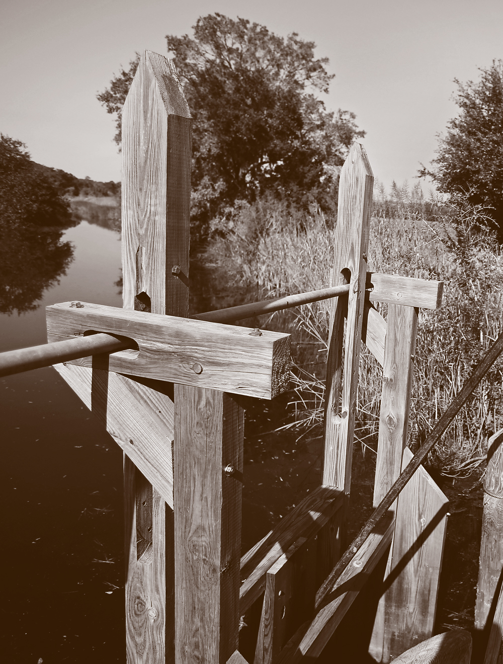
Altered Environment. Wooden trunks, like this one at Caw Caw Interpretive Center near Ravenel, allow the flow of fresh water into former rice impoundments. As more saline water moves inland, salt tolerant plants will take over. Photo by Grace Beahm Alford.
For nearly 50 years, a team of researchers has chronicled the slow changes in some of the formerly impounded rice fields at the nearly 3,000-acre Hobcaw Barony in Georgetown County. The property was designated for research and education work by former owner Belle W. Baruch after her death in 1964.
The team tracked vascular flora in three rice fields at Hobcaw in 1968-69, 1987-91, and 2013-15. The fields’ impoundment structures haven’t been operating for decades, so they have slowly reconnected to the estuary with natural water flow. The field with the highest salinity when the study began has seen little change in species. In the other two impoundments, the number of species dropped by 25 to 45 percent. Less salt-tolerant species disappeared as the sea level rose, and those species were replaced by smooth cordgrass (Spartina alterniflora), the dominant plant in coastal marshes, says Richard Stalter, a professor of biological science at St. John’s University in New York and one of the lead researchers.
As sea levels continue to rise and bring higher salinity into former rice impoundments, “salt marsh vegetation will replace the present assemblage of plant species,” Stalter says.
Migratory waterfowl that winter here could shift to wetlands slightly inland, but moving the grains that have been their supplemented food source to an area without impoundments will be difficult.
Let Nature Do Her Thing, or Use Engineering to Help
Scientists generally agree that the best thing humans can do is to get out of nature’s way. That has happened in a few places in South Carolina where waterfront property is owned by public agencies, producing boneyard beaches as sand and salt infiltrates former maritime forests on Pockoy and Bulls islands. Rice impoundment levees on Capers also have been allowed to collapse as water levels rise.
“There’s not really an option for us,” says Phil Maier, SCDNR’s manager of coastal reserves and outreach. “When those rice impoundments breach, they are still valuable for a variety of wildlife.”
The S.C. Department of Parks, Recreation, and Tourism (SCPRT) has adopted the policy of planned retreat of facilities and structures, according to Phil Gaines, who recently retired as director of state parks. At highly erosional Hunting Island State Park, the philosophy meant not rebuilding beachfront cabins after frequent storm damage in the past decade, and giving up 100 beachfront campsites after Hurricane Matthew in 2016. “We’ve been criticized for not putting the campground back because there’s room in there for some campsites, but it just doesn’t make sense,” Gaines says. “Mother Nature will win every time.”
The park has lost all of the cabins, half of the parking, and half of the campsites – and with them, lots of important revenue – to beach erosion. But the get-out-of-the-way policy applies only to structures so far. SCPRT decided to go ahead with a beach renourishment in 2019 on Hunting Island. The beach itself is too much of an economic engine for the community to give it up yet, Gaines says.
Other examples of human retreat along the South Carolina coast are rare, and extremely unlikely in densely populated areas. “We’ve changed the landscape with massive engineering, and we’re not inclined to move,” says Paul Gayes, director of the School of Coastal and Marine Systems Science at Coastal Carolina University.
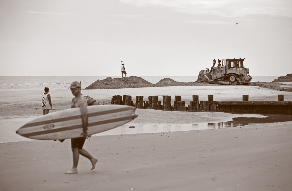
Engineering Solutions. Beach renourishment, such as this 2018 effort at Folly Beach, is done primarily to protect houses. As sea levels rise, innovative engineering also could protect or improve conditions for species of plants and wildlife. Photo by Grace Beahm Alford.
Gayes says the engineering focus needs to shift to methods that help nature deal with sea-level change. He cites as an example the ongoing effort to use dredge spoils from the Charleston harbor deepening project to build up Crab Bank. That manmade island in Charleston harbor has been a popular seabird nesting site until it eroded badly in recent years. Engineering expertise can be used to create more specialized habitat or make additional room for rising water.
“We would be well-served to try more experimental engineering approaches that might not have been considered in the past,” Gayes says. “Otherwise, we’ll be in emergency mode.”
Given Time, Nature Will Adapt to Rising Seas
For wildlife biologists, the first step in preparation for sea-level rise is to consider the potential effects. As so often happens when nature goes through changes, sea-level rise will have a mixed bag of impacts. Felicia Sanders, a bird biologist with SCDNR, says shorebirds for example could see short-term positive effects and longterm problems.
“Overall shorebirds like flat beaches with little vegetation, so newly eroded sites seem to be preferred by many shorebirds,” Sanders says. “But when the entire island erodes, or if the island is developed and the erosion hits development, the birds will be out of habitat.”
The USC Baruch Institute’s Morris says nature will adapt, and people will have to adjust to those adaptations. More open waters and fewer tidal wetlands could impact species of economic importance. Shrimp and menhaden could have less ideal nursery habitat. “We’re not going to lose things completely,” he says. “Just the amount and the placement will change.”
Room to Move. Natural systems along the South Carolina coast will adapt to sea-level rise, but those changes will be difficult in places such as this marsh behind Sullivan’s Island where development restricts marsh retreat. Photo/Grace Beahm Alford
SCDNR’s McCord recently returned to a hammock island near Bennett’s Point that he surveyed years ago. He was curious how a colony of rare plants had responded to being swamped by Tropical Storm Irma’s storm surge last year. “It knocked them for a loop, but they’re growing back in now,” he says.
University of South Carolina Naturalist in Residence Rudy Mancke has witnessed large-scale rebuilds up close. As host of South Carolina Educational Television’s “Nature Scene,” he saw first-hand nature’s ability to respond to the swath cut through South Carolina’s Francis Marion National Forest by Hurricane Hugo in 1989 and the radiation released in the 1986 disaster at the Chernobyl nuclear plant in Ukraine.
“I never expected the forest to recover as quickly as it did with Hugo,” Mancke says. “And I expected to see a war zone when we went to Chernobyl [in 2002], but it was not that way at all. We saw after Hugo, and we saw at Chernobyl, nature adapts. It just took a while.”
Because sea-level rise will require slow adaptation, Mancke thinks the natural environment will fare well. The warming climate that is driving sea-level rise already has prompted plants and animals to move. Some whose natural range used to be northern Florida are showing up in South Carolina now.
“We’re just going to end up with a different mix than what we have now,” Mancke says. “We’ll see more southern species moving north and more coastal species moving inland. When nature has an opportunity to fill spaces, she finds a way to do that.”
A few animal species, most notably sea turtles and shorebirds, will suffer from loss of specialized habitat that will be severely impacted by human development on coastal beaches. And some plant species that thrive only in the alkaline soil of hammock islands will have much less space to thrive. But Mancke remains upbeat.
“The more I think about it, the more I think that nature’s so resilient, the only species that’ll be terribly bothered is humans,” Mancke says.
Sidebar
Archaeology: Capturing the Past Before It’s Too Late
Archaeological sites are threatened by rising sea levels, as archaeologists work to document them before they disappear.
Millions of years ago, Earth’s oceans were nearly 230 feet higher, lapping at shores in what is now the Sand Hills belt of South Carolina from Aiken to Cheraw. Just 21,000 years ago, the ocean was about 410 feet lower than today, all the way out to the edge of the continental shelf.
In more recent times, the fluctuations have been smaller, allowing traces of human history to amass along the coast.
Archaeologists have been chipping away for decades at clues left behind in shell middens, or mounds, created by people who inhabited the South Carolina coast 4,000 years ago. The mounds themselves inform about social structures, as they likely were built by large groups gathered in the same spot at the same time of year for multiple years, says Sean Taylor, an archaeologist with the S.C. Department of Natural Resources (SCDNR).
The building blocks of the middens – predominately oyster and clam shells – also reveal details of the coastal ecology of the times. Tools made of shell and bone and decorated pottery hint of lives beyond the day-to-day struggle to survive.
Hundreds of shell middens dot the South Carolina coast, including publicly accessible shell rings at Sea Pines on Hilton Head Island and near the Sewee Visitor and Environmental Education Center in Awendaw. Others are on private land or surrounded by saltwater marshes. Some are underground.
On Botany Bay Plantation’s Pockoy Island, archaeologists spent three weeks in 2018 studying a recently discovered shell ring. LiDAR (Light Detection and Ranging) technology used to map elevation change in great detail located what appeared to be a ring in the island’s maritime forest.
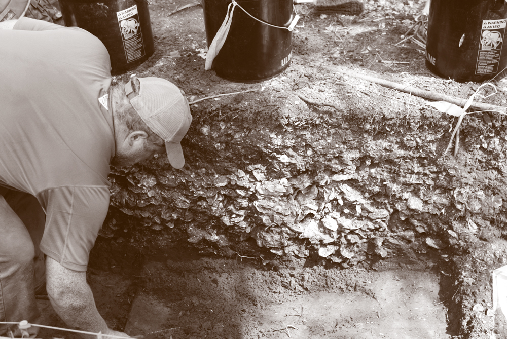
Historical Treasure. Shell middens such as this one on Pockoy Island hold secrets about past civilizations, and archaeologists are racing to document as many as possible before rising sea levels inundate them. Photo by Joey Holleman, S.C. Sea Grant Consortium.
A quick shovel test in 2017 found a type of pottery that indicated the site had been occupied about 4,000 years ago, Taylor says. More detailed transects every 33 feet confirmed a shell ring beneath the surface.
SCDNR, which manages the Botany Bay site, decided to schedule a dig. When Tropical Storm Irma’s surge ate away about 60 feet of Pockoy Island’s beach in September 2017, the dig took on new urgency.
“We’re trying to get this thing before the ocean does,” Taylor says while coordinating the dig in May 2018. “We’re about 60 feet closer to the ocean than we were a year ago.”
The shell ring, which had hidden under cotton fields in the 1800s and a maritime forest as the beach migrated inland in the late 1900s, could be washed away by the next strong storm surge.
Once shell rings fall to sea-level rise, “we don’t have the opportunity to learn about these people,” Taylor says.
The urgency holds true for hundreds of known archaeological sites. Tides already lap at the base of Fort Frederick, an 18th century British structure in Port Royal, South Carolina. Santa Elena, a National Historic Landmark and the site of a Spanish colony established in 1566, is barely above sea level. Fortunately, Santa Elena is on the U.S. Marine Corps training base at Parris Island, giving it an extra level of protection.
Pockoy Island, only a few feet above sea level and protected from waves by a small dune system, isn’t a site where major efforts will be made to protect the ring. So the only sensible step was to try to document the site, Taylor says.
The ring, clearly a human-built structure encircling an open shell-free plaza, is only about one to two feet high, not nearly as impressive size-wise as others nearby. But every one of these structures tells a little more of the story of the people who lived in the region 4,000 years ago – and each raises more questions, says Karen Smith, applied research division director at the S.C. Institute of Archaeology and Anthropology at the University of South Carolina. But this window on an ancient culture might not be available much longer because of sea-level rise.
“They were here for 4,000 years,” Smith says of the coastal shell middens. “And many of them are going to be gone in 40.”
Reading and Websites
Fuller, Roger and Nancy Cofer-Shabica. “Marshes on the Move: A Manager’s Guide to Understanding and Using Model Results Depicting Potential Impacts of Sea Level Rise on Coastal Wetlands ,” The Nature Conservancy and NOAA National Ocean Service Coastal Services Center, 2011.
McCalley, Matthew Owen. “GIS-Based Vulnerability Modeling of South Carolina Marsh Hammocks and Associated Species to Sea Level Rise,” Master’s Thesis, College of Charleston, 2012.
Miller, G.J., J.T. Morris and C. Wang. “Mapping salt marsh dieback and condition in South Carolina’s North Inlet-Winyah Bay National Estuarine Research Reserve using remote sensing,” AIMS Environmental Science, 2017.
Sandifer, Paul A., J.V. Miglarese, D.R. Calder, et al. Ecological characterization of the Sea Island coastal region of South Carolina and Georgia, Vol. III: Biological features of the characterization area, U.S. Fish and Wildlife Service, 1980.
Shelton, Stacy. “South Carolina: A Closer Look at Sea Level Rise on Cape Romain,” U.S. Fish and Wildlife Service, Open Spaces Blog, 2011.
Stalter, Richard, John Baden, and Dwight Kincaid. “The Vascular Flora at Three Abandoned Rice Fields, Georgetown, South Carolina: A 39 Year Comparison.” Journal of the Botanical Research Institute of Texas, Vol. 1, 2007.
Strand, Ginger. “A Safe Place to Land,” The Nature Conservancy Magazine, April/May 2016.
Whitaker, J. David, et al. “An Ecological Characterization of Coastal Hammock Islands in South Carolina ,” S.C. Department of Natural Resources, 2004.