South Carolina Water Level Monitoring Initiative
Overview of the Water Level Sensor Projects
The Southeast Coastal Ocean Observing Regional Association (SECOORA) has funded 4 teams to work on a 5 year (2020 – 2025) ‘Southeast Water Level Network’ project. The goal of the project is to install low-cost water level sensors across the southeast to help with coastal flooding challenges. These water level sensors will allow communities to observe real-time, publicly accessible data on the elevation of a waterbody’s surface in their community. This will help communities understand their localized flooding levels and take appropriate actions to prepare for the flooding, for example, block off low-lying roads that will flood.
The S.C. Sea Grant Consortium, in partnership with Coastal Carolina University, and Francis Marion University are engaging with communities in the Pee Dee region of South Carolina to install water level sensors throughout the Pee Dee River Basin. In addition to helping communities better understand localized water levels, the placement of these sensors also enhances the accuracy of flood modeling in the Pee Dee River Basin.
Beyond the Pee Dee region, the Consortium is leading regional coordination of Southeast Sea Grant programs that are also expanding water level sensor networks in Georgia, Florida, and North Carolina, through funding from SECOORA.

Why Does South Carolina Need Water Level Sensors?
The low-lying regions of South Carolina are highly vulnerable to flooding and have experienced repeated impacts from both extreme and chronic flooding over the last decade. The complexity of these tidal systems and their connection with upland watersheds combined with the lack of widely distributed monitoring equipment has resulted in a lack of understanding of how to prepare for and respond to these events for local communities.
What Are the Benefits of Real-Time Water Level Sensors?
Real-time water level sensors will help communities that are presently brought to a full stand still when flooding shuts down infrastructure and transportation corridors. Communities have the ability to set their critical water level threshold for flooding, which, when reached, enables them to enact protective measures such as blocking off low lying roads. The ability to plan, prepare for, and respond to flooding can decrease business interruptions and minimize property loss. These sensors will also allow communities to be better prepared for extreme events that may come in the future, by figuring out the early warning signs.
For example, if there is a flood and the community can see the water levels at the time of the flood and other external contributing conditions (e.g. tide, precipitation) that caused the water level, the community can respond quicker if those conditions are expected at a later date. Building out the network of water level sensors can also allow for communities downstream of a sensor to prepare based on water levels that they are observing upstream. There are also recreational benefits to having real-time data of water levels for boating and fishing. In terms of long-term adaptation the water level data may point to some opportunities to raise a road, enlarge a culvert, or raise a building. Finally, the web-based accessibility of these data to residents and visitors of coastal areas has the potential to increase the understanding of flood hazards and strengthen preparedness as communities adapt to a greater number and intensity of floods.

Isle of Palms water level sensor, photo by Nicole Elko, S.C. Beach Advocates.
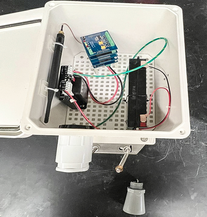
The inside of a water level sensor.
How Can a Community Receive a Water Level Sensor?
Communities can obtain water level sensors either co-funded or through grant funds. If the community is located in the S.C. Pee Dee River Basin or along the S.C. coast in an underserved community then they are eligible to receive a sensor with grant funding. Underserved communities are those that have been historically marginalized, under-resourced, and/or are environmentally vulnerable.
If your community does not meet this grant funded criteria you may directly reach out to a company such as Hohonu to obtain a water level sensor; see costs below.
What is the Cost of a Water Level Sensor?
SECOORA (grant funded): If a community is financially able, there is a one time cost of $500 to help purchase the sensor. The project team has some funds set aside to cover this cost for underserved communities who cannot afford this cost.
Once the sensor is installed and the grant period is over in 2025, the community will have to assume the ongoing cost for the cell service (approximately $20/month).
Hohonu* (non-grant funded): $2,100/yr. This includes hardware, software, and data service and storage. More information.
Please note: The Consortium does not have any formal business relationship with Hohonu. The Consortium and partners had previously worked with Hohonu to install grant-funded sensors, but those specific grant funds have expired. Communities that do not qualify for grant-funded sensors are welcome and encouraged to consider other sensors not produced by Hohonu.
Where to Install a Water Level Sensor
- Locally owned bridges (County or private) not owned/maintained by S.C. Department of Transportation (SCDOT). If a bridge is owned/maintained by SCDOT it will take longer to obtain permission to install a water level sensor.
- Locally or organizationally-owned docks or piers in low traffic areas (e.g. without frequent fishing or boating activity beneath the sensor.
- Locations where other parameters are already being measured, ie. weather stations or water quality. This will help scientists to correlate all measurements to one location.
- Areas of transition or confluence, multiple rivers coming together, land use changes (ie. agriculture to urban), rivers meeting ocean, upstream of a residential area known to flood.
Other Site Conditions to Consider
- Site should have access to a Verizon cell signal for data transmission
- Site should have direct sunlight for solar panel to charge batteries
- Water level sensor needs to be mounted between 5 -10 meters (16- 32 feet) above water surface
- Constant inundation below the sensor location (e.g. an area that does not convert to mud flats during a portion of the tide cycle or during dry periods)
- Installing on an existing structure is easier, i.e. bridge railing or pole
- No obstructions between water level sensor and water level (i.e. tree branches)
Where Can the Water Level Sensor Data be Viewed?
Pee Dee Water Level Sensors
Hohonu Water Level Sensors
All Water Level Sensors
Locations of Water Sensors
Does not include water level data, shows the spatial coverage of various kinds of water level and river gauges.
Who Can be Contacted for More Information About Getting a SECOORA (Grant-Funded) Water Level Sensor?
Katie Finegan (S.C. Coast) katie.finegan@scseagrant.org
Ke’Ziyah Williamson (Pee Dee Region) keziyah.williamson@scseagrant.org